Malegaon Fort is land fort traced in the busy Malegaon town. It is situated 104 km from Nashik, in Nashik district, of Maharashtra. This fort is on the north bank of famous Mausam river which is a tributary of Girna river and was built during the great Maratha Empire.
In 1740, this fort was constructed by Naro Shankar Raje Bahadur the general of Peshwa. He was appointed as an agent in Malwa.
He was gifted 18 villages which included Malewadi.
The crafts men were brought from Surat and northern India to build the fort. It took about 25 years to build the fort.
After the fort was completed the craftsmen settled in the town. In 1816 Dilawar Khan a Rohill sepoy first constructed an Idgah in the town.
After the fall of Trymbak fort on 24 May 1818, this fort was besieged on 16 May 1818 by the East India Company.
This fort was built by Naro Shankar who was the younger brother of the Chhatrapati Shahu II of Satara, Chatursingh declared a war against the Peshwas and took shelter in this fort.
The Peshwa commander Trimbakji Dengle captured him inside the fort in a crooked way on 10th January 1810. After the Peshwas, Arabs had control over it. On 16th May 1818, British army attacked the Arabs, who 300-350 of them held the fort for a month’s period. On 10th June 1818, when the canon fired from the British exploded the pile of ammunition on the fort, the Arab defence went weak and they had to surrender on 13th June 1818.
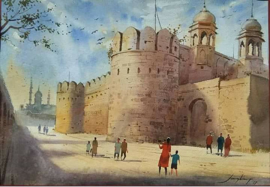
Present Condition The fort is in good condition. The height of the inner wall is 60 feet. The fort has lofty entrance gates. The thickness of the walls is about six feet. There are two cannons at the entrance door and there is a hexagonal well inside the fort. It takes about an hour to see the fort.
In 1740 the Sardar of Peshwas Naroshankar built and named it as a Bhuikot Killa (fort that is built on flat land and not on any mountain), Bhui means Land in Marathi. The fort is now known as Malegaon Fort. There is no name anywhere or any evidence that can prove that this fort was built by Naroshankar, says reports of archaeology.
The fort is close to the city and as Malegaon is connected by the Mumbai-Agra highway, it is very easy to access the fort. The fort is very close to Mausam river. The fort is in square shape in 100.33 square metre area. There are two security walls built around the fort with burnt bricks. The walls are 20 m in height and 3.35 m width. Having a trench on all its sides is very important for the security of any land fort and Malegaon fort has it on its four sides.
By building a wall partition in the river, the water is diverted into this trench. There was a collapsible bridge built on this trench. Only one side’s trench is left presently, rest all have been wiped our due to increased colonization. The fort had three layers of fortified walls.
The outside layer has lost in the housing colonies.
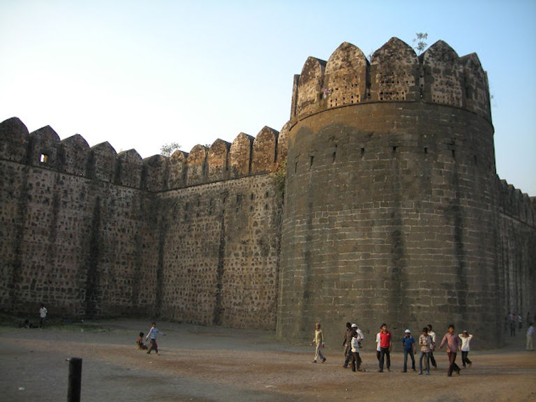
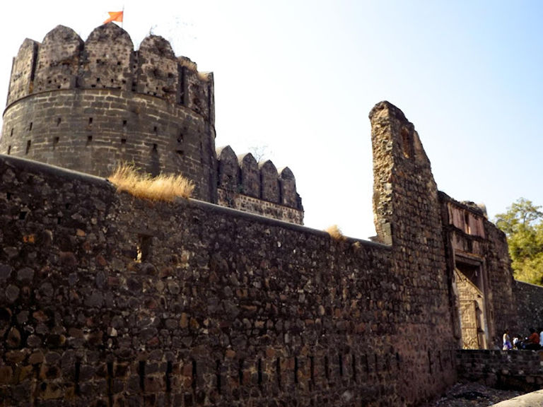
Only one bastion to the river side is standing as of now. The fortified wall to the west has been cut to provide access for the Kankni Vidyalala School inside the fort premises. This is the main entrance of the fort. After entering, we can see the new school building and 3 canons in its front. Facing the school, one can see a space in the two fort walls from where the fort tour can be started. The inside fort wall is 20 feet high and has 9 bastions in it.
On the fort wall there are narrow windows built and a place to stand. The second bastion which is on the outside does not have any bastion and is 15 feet high. There are narrow windows here too. Below the fort wall there are small rooms with dimensions of 2 X 2 X 3. The exact purpose of these rooms isn’t known.
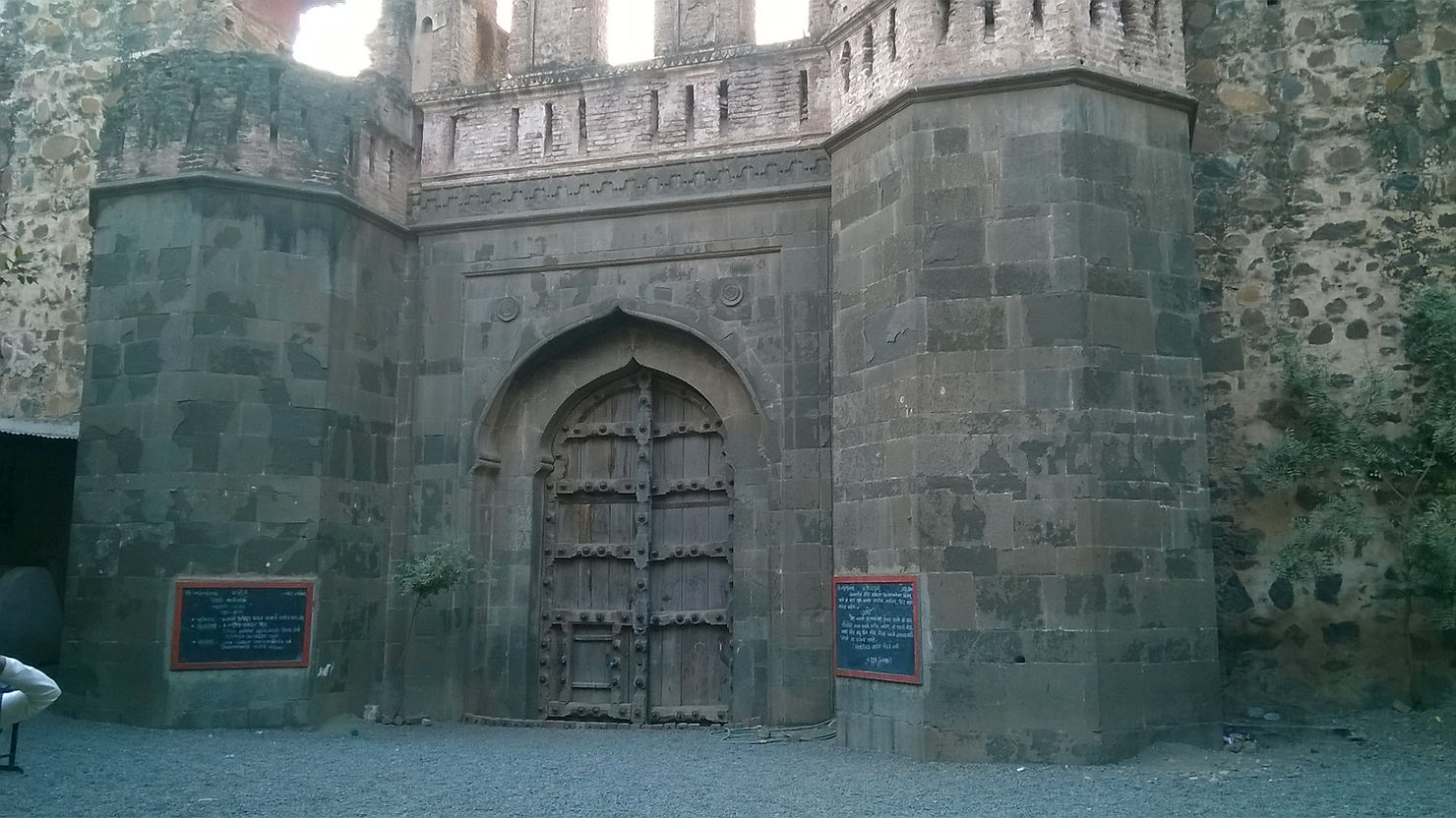
To circumvent tor fort between the walls it takes about 15 minutes. A door has been cut through the wall between two bastions for the school. Use the way between the school and the left bastion and proceed ahead. One comes across a huge entrance here. The wooden door is still intact. And is locked from outside.
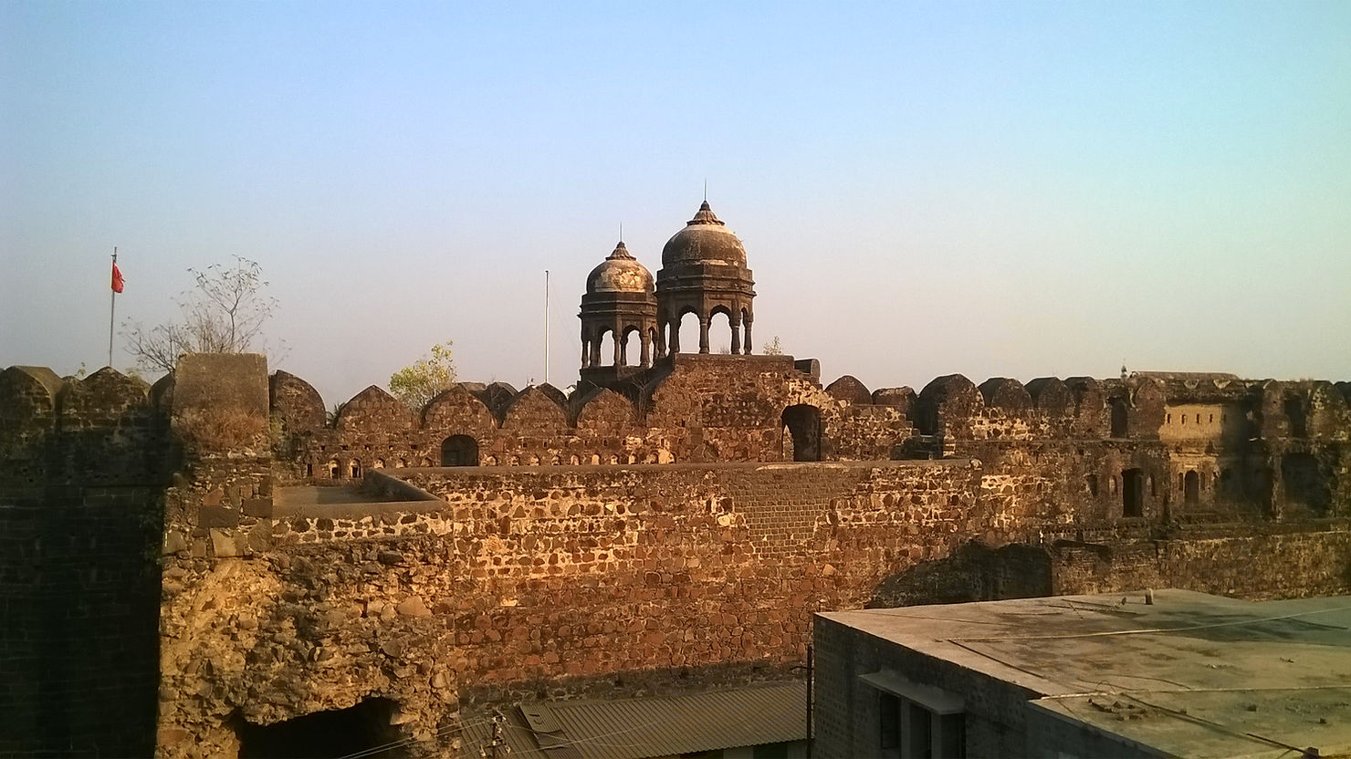
This 20 feet high door has two bastions besides it which have carvings of lotus on its arcs. There is a brick construction of about 10 feet high on the door and the bastions. There are 3 windows built on each door and the bastions.
On the right side of the door there was a two storied structure and its top floor was dedicated for recreational and entertainment activities. Present day, the ground floor hosts the school and as the slab between the two floors have been collapsed the upper floor is inaccessible now.
Historical Significance
The river Mausam acts as a natural protection to the fort. There are also trenches built for security with 25 feet depth and 16 feet width. The trenches were used to get filled with the river water, as per the archaeological report. There is only one way to enter the fort, after crossing the trench there are two doors from where one can enter into the fort. There is a place between the fort wall and the door to attack, which is a common in every fort structure.
There is only one structure remaining in fort which is called as ‘Rangmahal’. The stables, rooms for soldiers and steps to go up on the security wall are build by using the width of the security wall. The fort has wells built on west and south- west side. Bastions are built on all sides of fort with place for cannons. Though the fort was build by Naroshankar as per traditional saying, the fort was in the control of Peshwas as he was their cavalier.
After the defeat of Peshwas in 1818 by the British, all the forts in Maharashtra were captured by them and this fort was no exception. The story of capturing this fort is documented by British. In the book ‘Marathyanchya Ladhaicha Itihas’ by Paranjape, the reference of this document is given. Accordingly, On May 16, 1818, Lieutenant Colonel Macdowell surrounded the fort with his soldiers.
The British were unaware about the strength of the fort and they took it lightly as the fort was small. After trying to break into the fort, they succeeded in breaking a part of a wall, but when they did, there was another wall waiting for them. By seeing this Lt Natis, a british engineer, tried to climb the other wall by using ladder but the ladders collapsed and Natis got killed.
The camp of Macdowell was in south and after that it was moved to right side of the Mausam river. As it was a starting of the rainy season the camp faced threat of flood in river, so they moved the camp to town side. By taking shelter on south of the river under trees, the soldiers started cannon attack on fort. A trench parallel to river was dug by the British. The army of Britishers was increasing every day but the Arabs in the fort got locked in the fort. From May 16 to 29 British forces tried to conquer the fort but failed.
On June 1 the camp was moved again and on June 5, attack was made with a howitzer cannon but it was of no use. Then more cannon forces were called from Ahmednagar. On the morning of June 11, two gun powder store rooms of the fort came under fire and because of its blast, the walls of the fort collapsed and finally on June 13 , the fort was captured by the British.
Malegaon fort also known as Mahuligram fort is located on the confluence of Girna (Giriparna) and Mosam(Mokshini) rivers. Built in the 18th century, this fort now hosts a school inside its premises and is still in a good condition.
Played a role in Modern History of India
The people of Malegaon had responded to Khilafat & Non-Cooperation movement of 1920 with enthusiasm. They’d boycotted British institutions, set up their own courts & picketed liquor shops. The British provoked violence in order to clamp down against revolutionary activities. In a clash between the revolutionaries and police, a native constable was killed.
The revolutionaries took over control of the city, British flag was downed from Malegaon fort & replaced with an Indian flag.
Nearby Facilities for Visitors Accommodation Facility : Available at Malegaon
Food Facility : Available at Malegaon
Time To Reach : 15 minutes from Malegaon S.T. bus stand.
Best Season To Visit : Throughout the year
Type : Land Forts Fort Range : Nil
District : Nashik Grade : Easy
Who was Naroshankar Rajebahaddur ?

Sardar Naroshankar Rajebahaddur was a brave and able soldier in Peshwa regime from 1706 to 1775. He was incharge of the wealth of the Peshwas and after the war of Panipat, he left the wealth irresponsibility, so the Peshwas were unhappy with him for some time. He had spent considerable period in North India, so was in company in company with Antaji Mankeshwar Hinghe and was considered as an information agent. Naroshankar had built the fort of Malegaon.
Naroshankar Temple And Ghanta [bell]
Situated on the banks of the sacred river Godavari, Naroshankara Temple is an ancient temple dedicated to Lord Shiva. The temple was constructed by Sardar Naroshankar Rajebahaddur in 1747 and hence got the name Naroshankar temple.
The Naroshankar Temple is a great example of the architectural style called “Maya” dating back to the 18th century. The main temple is built on a platform and its interiors as well as exteriors are adorned with stunning carved structures and ornamental works that contains elaborate laceworks, peacocks holding bead garlands etc. The four directions of the temple are adorned with statues of the saints in Padmasana and its four corners are decorated with umbrellas, commonly known as ‘Meghadambari’ or ‘Barasati’, of which only three are existing, the other being washed away in Godavari floods. The temple is surrounded by a 11 feet fortification with a huge bell house in its center which houses the famous Naroshankar Ghanta bell. The bell house is a memorial to celebrate the victory over the Portuguese by the Maratha Ruler Bajirao Peshwa’s younger brother Chimaji Appa who won the fort of Vasai from the Portuguese. Naroshankar Rajebahaddur had played a vital role in this war and the bell is awarded to him for his bravery. The ringing of this bronze bell measuring six feet diameter can be heard up to about 5 kilometers.
“The cities having forts are privileged for these are rare gems amidst sprawling beads of malls”
Leave a Reply