
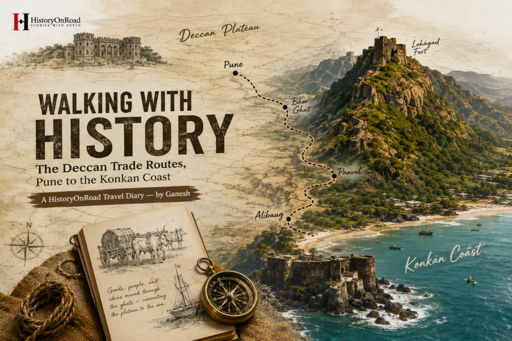
A HistoryOnRoad Travel Diary — by Ganesh
Some journeys are about distance. This one was about descent.
Long before highways cut through them in straight, confident lines, the Sahyadri hills separated two very different worlds — the wide, dry plateau of the Deccan, and the narrow, humid strip of the Konkan coast below it. For centuries, the only way to move goods, people, and ideas between them was through a handful of steep mountain passes, known locally as ghats — routes carved as much by necessity as by geography.
Cotton, grain, and other Deccan produce went down. Salt, fish, spices, and imported goods from ports along the Arabian Sea came up. Somewhere in the middle of that exchange, forts rose along the ridgelines — not for scenery, but because whoever controlled a ghat controlled everything that passed through it.
I wanted to retrace that descent myself — starting in Pune, ending at the coast — and see how much of that old rhythm still lingers beneath the modern roads.
Day 1 — Pune: The Plateau’s Old Marketplace
Pune didn’t start as a capital. Long before it became associated with Maratha power, it was simply a convenient stop — a market town positioned where routes from the northern Deccan met paths heading toward the western ghats.
I spent my first morning near Shaniwar Wada, the old fortified palace at the city’s centre, trying to picture Pune not as it is now — traffic, tech parks, university crowds — but as a smaller settlement built around exchange. Grain merchants, cloth traders, and moneylenders would have set the city’s daily rhythm long before any army did.
By afternoon, I walked through one of Pune’s older markets, still humming with the same basic function centuries later — bargaining, weighing, wrapping. An elderly cloth seller, noticing me lingering near his stall, told me his family had traded fabric in this same lane for four generations. “Route badalte gaye,” he said — the routes kept changing — “pan dukaan tithech rahili.” But the shop stayed right here. It felt like the perfect opening line for the journey ahead.
Later, I wandered past a row of old grain warehouses near the market’s edge — solid, thick-walled structures, clearly built for storage rather than display. A local historian I’d arranged to meet explained that towns like Pune functioned as collection points long before they became political centres: grain, cotton, and cloth from surrounding villages were gathered here first, sorted and priced, before merchants decided which route — and which coastal port — offered the best return that season. Trade, in other words, shaped the city’s geography well before any fort or palace did.
Day 2 — Lonavala and the Bhor Ghat: Where the Plateau Ends
Leaving Pune, the land begins to change quickly. Within an hour, the flat plateau gives way to the first real hills, and by the time I reached Lonavala, the air itself felt different — cooler, damper, carrying the first hints of the coast still many kilometres away.
This stretch follows, roughly, the old alignment of the Bhor Ghat — one of the most heavily used passes connecting the Deccan to the port towns below. Long before the railway line was blasted through these same hills in the 19th century (itself a remarkable feat of engineering, cutting tunnels and viaducts through solid rock), traders used a narrower, steeper track here, moving bullock carts and pack animals down gradients that modern vehicles still approach carefully.
I stopped at a viewpoint overlooking the ghat’s descent, watching clouds roll into the valley below in slow, deliberate waves — a sight locals call the dhaba monsoon view, since so many small roadside eateries here exist purely to let travellers pause and watch exactly this. I ordered spiced tea and simply sat for a while, doing what generations of traders before me had probably also done at this exact bend in the road: catching their breath before the steep part began.
Day 3 — Lohagad and Visapur: Forts That Watched the Trade
A short detour north of the main descent brought me to the twin forts of Lohagad and Visapur, standing across a narrow valley from each other like old sentries still on duty. Neither fort was built for comfort — narrow stone steps, steep climbs, walls designed to be defended, not admired.
Standing at Lohagad’s edge, looking down at the valley the old trade route once threaded through, the fort’s purpose became obvious without needing much explanation. Whoever held this height controlled visibility over a significant stretch of the route below — who was moving through, what they were carrying, and whether they intended to pay the tolls expected of them.
A local guide, who’d walked this fort more times than he could count, mentioned that during the Maratha period, a functioning network of forts like this one didn’t just defend territory — it actively protected trade, offering merchants safer passage in exchange for a share of what they carried. It reframed something for me: these forts weren’t just about war. They were also, in their own way, an early form of trade infrastructure — insurance, checkpoints, and shelter, built out of stone.
Inside Lohagad’s outer walls, I found a long stretch of stepped stone flooring, worn smooth in a way that seemed too even to be accidental. My guide agreed — centuries of feet, hooves, and cart wheels, he said, could polish stone just as effectively as any river could. It was a small detail, easy to walk past without noticing, but it stayed with me: proof, quite literally underfoot, of how much regular traffic this route once carried.
Day 4 — Down Through the Ghat: Panvel and the Coastal Plain
The descent itself is where the old route’s logic becomes physical. Within a short stretch, the temperature climbs, the vegetation thickens, and the wide views of the plateau disappear behind closer, greener hills. By the time I reached Panvel, on the edge of the coastal plain, the Deccan already felt like a different journey entirely.
Historically, towns like Panvel functioned as transfer points — the last stop where goods coming down from the plateau were reorganised before continuing to the coast, and where goods coming up from the ports were loaded onto carts and pack animals for the climb ahead. Even today, Panvel retains something of that transitional character — a town that feels less like a destination and more like a hinge between two very different regions.
I ate lunch at a small coastal-style thali place here — the first hint, on this journey, of Konkan flavours: coconut, kokum, and fish, replacing the wheat- and jowar-heavy plates I’d eaten in Pune just two days earlier. Food, I realised, had quietly been tracking this journey’s geography as accurately as any map.
Day 5 — The Konkan Coast: Where the Route Meets the Sea
The final stretch brought me to the coast itself, near Alibaug — a stretch of shoreline that historically connected to a wider network of Konkan ports, some of which, centuries ago, traded directly with Arabia, Persia, and beyond. Standing on the beach, watching fishing boats head out in the early evening light, it was hard not to think about how much distance separated this exact spot from where I’d started, in Pune’s old cloth market, just days before.
Nearby, weathered sea forts — built to guard harbours rather than mountain passes — mark a different chapter of the same story: once goods reached the coast, an entirely separate set of concerns took over. Piracy, naval control, and maritime trade with distant lands replaced the ghat’s concerns of gradient and tolls.
I spent my last evening simply walking along the shore, watching the tide come in over rocks that had likely watched centuries of the same exchange — goods arriving by sea, goods departing by land, and an entire economy quietly built on the cooperation of two very different landscapes.
What the Descent Taught Me
Retracing this route left me with a simple realisation: trade routes are rarely just lines on a map. They’re negotiations with geography — a plateau that produces grain but has no port, and a coastline that has ports but limited farmland, each depending on the other, connected only by a handful of difficult, well-guarded passes.
Pune gave this journey its starting rhythm — markets, bargaining, exchange. The ghats gave it drama — forts, altitude, and the physical labour of descent. And the Konkan coast gave it an ending that felt less like a destination and more like an opening onto something larger — the sea, and everything it once connected this stretch of coastline to.
I didn’t just travel from Pune to the coast. I travelled, in a small way, through the logic of an entire regional economy — one shaped as much by hills and monsoons as by any ruler’s ambition.
This is the third entry in HistoryOnRoad’s ongoing travel diary series.